#Fotos:Lluvias dejan 64 muertos y 65 desaparecidos en México

  • El gobierno federal confirmó víctimas mortales y daños graves en 111 municipios del país.

México, 13 de octubre.- Desde Palacio Nacional, la coordinadora nacional de Protección Civil, la historiadora del arte Laura Velázquez, informó que 64 personas murieron y 65 permanecían desaparecidas tras las intensas lluvias registradas en gran parte del territorio nacional.

Imagen

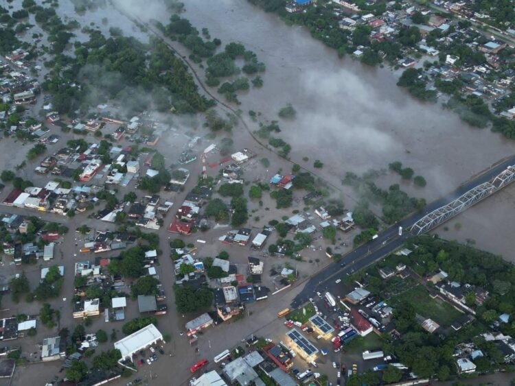
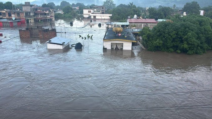
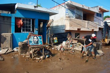
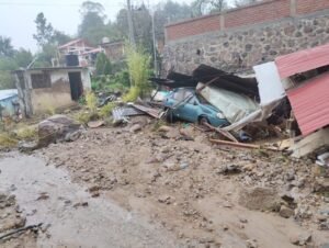
Durante la tradicional conferencia de prensa desde Palacio Nacional, la funcionaria señaló que 111 municipios en total resultaron afectados, con los mayores daños en Veracruz, Hidalgo, Puebla, San Luis Potosí y Querétaro, donde las precipitaciones provocaron deslaves, desbordamientos y cortes de energía.

First image displays an aerial view of a flooded urban area in Poza Rica Veracruz with brown muddy water covering streets and low-lying zones near a bridge surrounded by scattered buildings and trees. Second image captures similar flooding along a riverbank with water inundating neighborhoods and green patches amid residential structures. Third image shows broader flooding in a town setting with water spreading across multiple areas including warehouses and roads under cloudy skies.

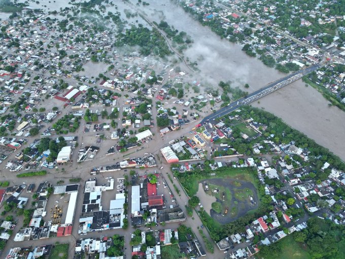
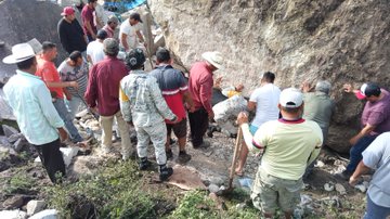
De acuerdo con el reporte oficial, el gobierno federal activó operativos de emergencia para atender a las comunidades más vulnerables, particularmente en la Sierra de Hidalgo y las zonas costeras de Veracruz.

Floodwaters surround several low-rise buildings in a residential neighborhood, with some structures partially submerged and others elevated on stilts. Debris floats in the murky water, and green trees stand nearby. A few people are visible on rooftops or wading through the water, indicating a recent heavy rain event causing widespread inundation.

Estados con prioridad de atención

En Veracruz se contabilizaron 40 municipios afectados, de los cuales 22 fueron catalogados como prioritarios. En ese estado se confirmaron 29 fallecimientos y 18 personas desaparecidas, informó Protección Civil.

First image shows several uniformed personnel in camouflage wading through shallow floodwater on a rural road lined with green vegetation and power lines under a blue sky with clouds. Some carry items others walk beside a white truck loaded with people including children in casual clothes. Second image depicts four uniformed personnel with yellow armbands at a muddy area near a wall and vehicles in background two hold shovels and a large white sack others stand nearby with green fabric and tools on ground. Third image features a uniformed personnel holding a brown box assisting an elderly woman in blue sweater and skirt walking on a muddy street with buildings power lines and another person in background.

En Hidalgo, 28 municipios sufrieron daños, 23 de ellos con prioridad. Las autoridades registraron 21 muertes y 43 desaparecidos, principalmente en la región de la Sierra Alta.

First image shows several uniformed personnel wearing yellow helmets and dark clothing labeled Marina assisting a child in orange clothing near a wheelbarrow filled with mud in a flooded area surrounded by greenery plants and simple structures under overcast skies. Second image depicts a red backpack marked with reflective strips carried by a person in blue uniform labeled Marina interacting with elderly women and men in casual attire including hats and floral dresses near trees and rocks in a wooded setting. Third image captures a white helicopter marked Marina landed on a muddy hillside with mountains in the background uniformed personnel in blue loading boxes while civilians including children and adults in casual clothes stand nearby holding supplies under cloudy weather.

En Puebla, 23 municipios fueron afectados y 17 se declararon en emergencia, con 13 personas fallecidas y cuatro desaparecidas, según los datos federales.

First image shows multiple people including uniformed personnel in camouflage and civilians in casual clothing gathered around a large rocky slope with a massive boulder partially dislodged holding shovels and tools preparing to clear the obstruction. Second image depicts a group of individuals surrounding an enormous gray rock embedded in the ground amidst green vegetation with some using shovels to dig around its base while others stand nearby observing. Third image captures uniformed members in tactical gear and locals near collapsed structures and debris piles in a hilly area with scattered rocks and a red container visible on the ground. Fourth image illustrates personnel in camouflage uniforms assisting with blue tarps and wooden debris in a forested clearing with tents and damaged materials suggesting ongoing recovery efforts.

Acciones del Ejército Mexicano

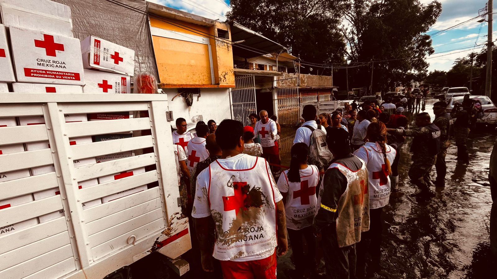
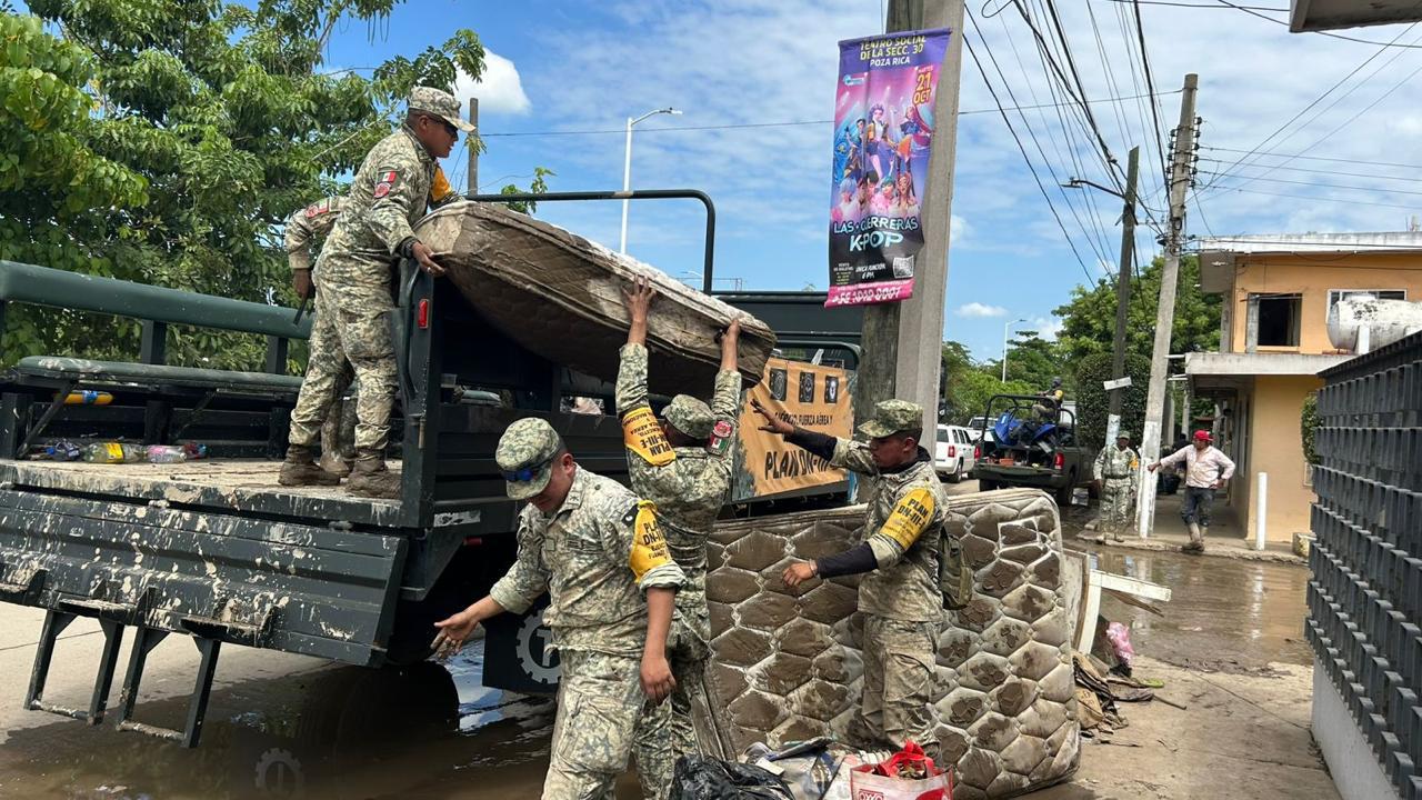
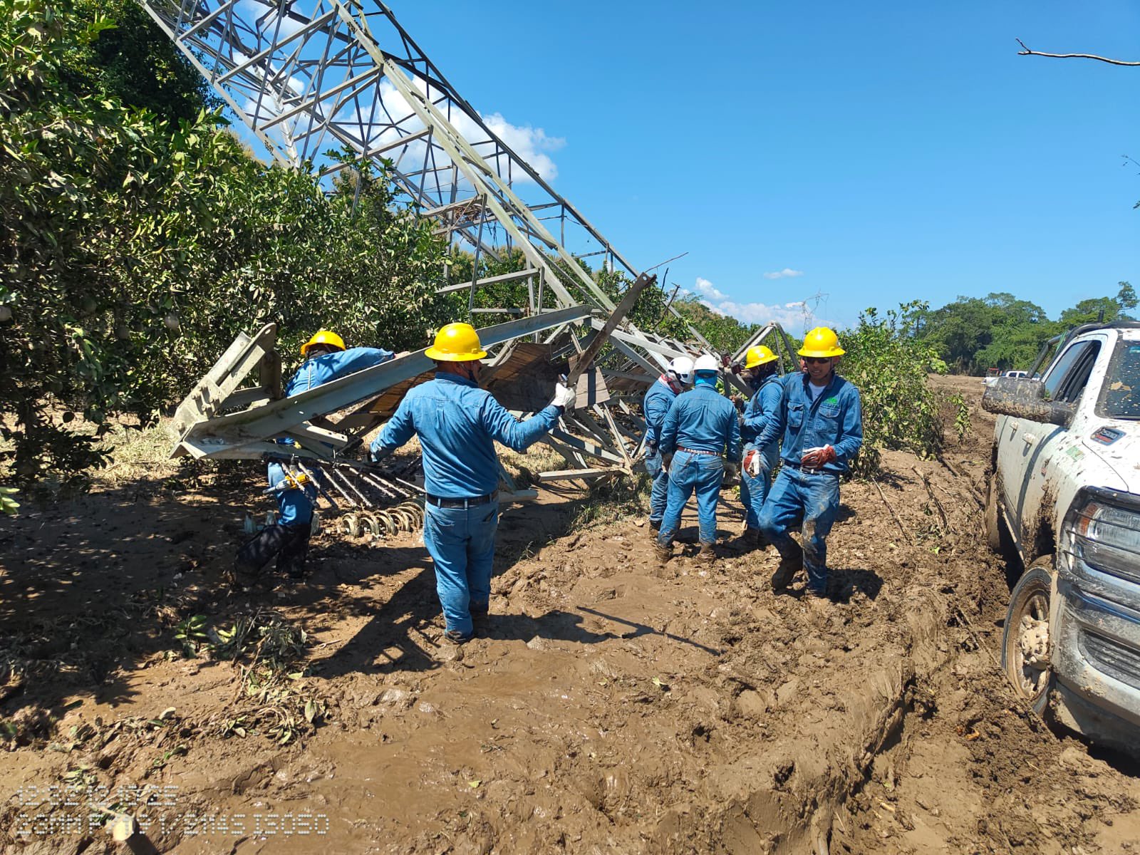
El general Ricardo Trevilla Trejo informó que desde la madrugada del 9 de octubre se desplegó el Plan DN-III-E, coordinado por el Ejército Mexicano, la Fuerza Aérea y la Guardia Nacional.

First image shows a man in red shirt and jeans standing in muddy floodwater on a street lined with trees, vehicles, and buildings in Mexico, with a yellow pedestrian sign visible. Second image depicts navy personnel in blue uniforms using shovels to clear mud and debris from a flooded area near a tree and pink wall, with a bucket and map overlay indicating Venustiano Carranza in Hidalgo and Veracruz. Third image features a uniformed soldier in camouflage carrying a baby in red clothing through shallow floodwater beside a damaged red car and collapsed structures. Fourth image illustrates responders in dark uniforms carrying a person on a yellow-handled stretcher through deep muddy water, with a dog nearby and trees in the background.

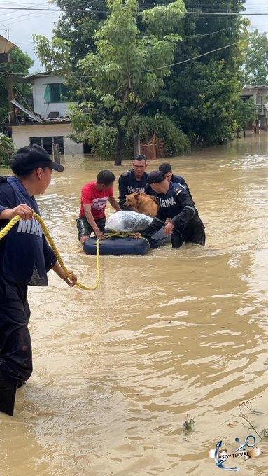
En total participaron 7 mil 347 elementos, apoyados con siete aeronaves, tres plantas potabilizadoras, 40 unidades de maquinaria pesada, 16 drones de vigilancia y siete binomios caninos.

Imagen

Las autoridades también habilitaron dos cocinas móviles, 11 lanchas y seis tractocamiones para el traslado de víveres, así como 31 camiones de volteo para el retiro de escombros.

Recursos para emergencias ambientales

Imagen

La mandataria Claudia Sheinbaum informó que el gobierno federal tenía disponibles 19 mil millones de pesos en reservas para atender desastres naturales.

First image shows a young woman with long dark hair wearing a gray t-shirt and denim shorts sitting on a muddy street surrounded by floodwater piles of trash plastic containers and debris near metal gates and buildings in an urban alley. Second image is an aerial view of a flooded neighborhood with brown water covering the ground cars partially submerged laundry hanging on lines trees and white multi-story buildings along the street with scattered debris. Third image depicts a yellow two-story house partially submerged in floodwater with green trees around scattered trash boxes and plastic bottles floating in the muddy water. Fourth image features a man in a black cap and t-shirt using a shovel to clear mud and debris near a blue house with a painting of Jesus on a wooden stand and scattered wood scraps in the foreground.

De esa cifra, tres mil millones fueron utilizados para operaciones de emergencia, transporte aéreo y mantenimiento de equipo destinado a las tareas de rescate.

Sheinbaum precisó que los fondos permitirán sostener las labores de reconstrucción y apoyo humanitario durante las próximas semanas.

Atlas de riesgo y prevención

La funcionaria federal destacó la importancia de actualizar los Atlas de riesgo en todos los municipios del país, como herramienta para prevenir daños ambientales y proteger a las comunidades vulnerables.

First image shows multiple soldiers in camouflage uniforms with yellow armbands digging and shoveling mud on a steep, tree-lined hillside path during foggy weather. Second image depicts a group of soldiers in similar uniforms standing near a large excavator with an extended arm loading mud from a roadside area surrounded by trees and fog. Third image captures two green military trucks parked on a grassy roadside with soldiers inside, one truck displaying a banner in Spanish. Fourth image features a yellow military truck and a blue dump truck on a roadside with green vegetation and a utility pole nearby.

Explicó que los registros ayudan a identificar zonas propensas a inundaciones, deslizamientos o desbordamientos de ríos, lo que facilita una respuesta más rápida en casos de emergencia.

Imagen

Añadió que el fenómeno climático afectó principalmente el oriente del país, donde varios asentamientos se ubicaron cerca de cauces naturales que sobrepasaron su capacidad.

Imagen


(Con información de Sociedad-Noticias)

Fotos:Redes Sociales